The Quebec weather forecast warns of more tornadoes and 'violent' storms this summer
There's a very specific reason for these conditions.
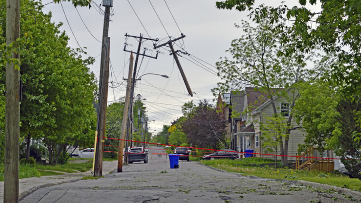
An electrical grid post with power lines is snapped in half after a massive storm in Quebec, Canada.
Late Monday afternoon, Quebec was hit with its first tornado of the year, damaging homes in the Montérégie region, just 70 kilometres west of Montreal. Meanwhile, Montreal was under a severe thunderstorm watch, as strong winds gusted and rain poured, ultimately leaving tens of thousands of people without power.
Unfortunately, according to the Quebec forecast, this isn't the last we'll see of this sort of weather in the next few months — and it's all thanks to two climate patterns called El Niño and La Niña. If you're reading this El Niño and La Niña, that "thanks" was sarcastic.
What is El Niño?
Scientists predict that a weather phenomenon called La Niña will return as early this summer, replacing El Niño, which has been in effect since the summer of 2023.
El Niño (little boy in Spanish) is the "unusual warming of surface waters in the eastern tropical Pacific Ocean," as per National Geographic. In other words, it makes sea-surface temperatures a little bit warmer than normal, which doesn't seem like that big of a deal, but can actually have a big impact on global weather, winds, wildfires, ecosystems and economies.
In fact, El Niño is partially responsible (in addition to factors like global warming) for the mild winter we had here in Montreal, as well as those sudden extreme flips between historically warm and historically chilly temperatures.
El Niño occurs every two to seven years while La Niña typically occurs every three to five years.
What is La Niña?
La Niña (little girl in Spanish) is the opposite of El Niño — it's the cooling of surface-ocean waters, bringing cooler-than-normal temperatures to the southern Pacific off the coast of South America, National Geographic explains.
The transition between El Niño and La Niña is expected to happen quickly, The Weather Network says, with La Niña dominating this summer after a short neutral period.
How will the transition from El Niño to La Niña impact Quebec weather?
Jana Lesak Houser, associate professor of meteorology and atmospheric sciences at Ohio State University, explained via The Weather Network that "when El Niño decays, the atmospheric waves change and can become wavier, so they have a greater amplitude. That tends to enhance conditions needed for tornadoes."
These conditions, ripe for warm moist storms, can also bring heavy rain storms, flash flooding and hail.
While El Niño is forecasted to be gone by summer, that's right in time for La Niña to take over. An abrupt flip flop between El Niño and La Niña has been known to lead to an active Atlantic hurricane season.
Not only does this impact weather in Canada's Atlantic provinces, but also in surrounding parts of Eastern Canada, including Ontario and Quebec, as remnants of hurricanes and storms that hit other places make their way over, causing widespread flooding, wind damage, and even tornadoes.
When La Niña is present, we "generally observe summers richer in violent weather in Quebec," MétéoMédia says, and last La Niña, in the summer of 2022, Ontario and Quebec even experienced a derecho — a fast-moving wind storm associated with a line of intense thunderstorms.
"The combination of very warm water and La Niña in full bloom during the late summer and early fall has forecasters worried," The Weather Network reports. "Experts across the board expect an extremely active Atlantic hurricane season this year, which could increase the risk for active weather across the East Coast [of Canada], as well as parts of Ontario and Quebec."
This isn't the greatest news to hear as summer approaches and the city comes to life. But there's not much we can do besides bolt down our outdoor furniture, invest in some high-quality rain-gear and take full advantage of any nice days ahead.
This article's cover image was used for illustrative purposes only.
- Montreal Summer Would Be Ruined If This Quebec Weather Forecast For July Actually Comes True ›
- Montreal is under a severe thunderstorm watch — and there's a tornado warning nearby, too ›
- Canada’s Winter Weather Forecast Is All Over The Place Thanks To El Niño ›
- Montreal weather will sizzle this week with a possible heat wave that ends in a downpour - MTL Blog ›
- Montreal weather is under a severe thunderstorm watch and F1 weekend is gonna be a wet one - MTL Blog ›
- There are now 2 Montreal weather alerts in effect at the same time, as thunderstorms loom - MTL Blog ›
- Footage of Montreal's record-breaking rainstorm causing major floods and total chaos - MTL Blog ›
- Montreal Weather: 'Severe' thunderstorms — and even a tornado — could be on the way - MTL Blog ›
- Quebec's fall weather forecast just dropped and we're in for a 'frosty and unsettled' season - MTL Blog ›
- Montreal weather in August will be 'warmer than normal,' as meteors light up the night sky - MTL Blog ›